
Qeshm is the largest island in the Persian Gulf — around fifteen hundred square kilometres, a hundred and thirty-five kilometres from end to end, lying so close to the mainland that the ferry from Bandar Abbas takes under an hour. It is also the least Persian place in this blog. There are no Safavid squares here and no gardens; there is salt, rock, mangrove and the sea, and a landscape that looks like nowhere else in Iran.
The island carries a UNESCO Global Geopark — the first in the Middle East — and that designation is the honest description of what you come for. A salt cave over six kilometres long. A gorge fluted like the inside of a shell. Tidal forest you enter by boat. Travellers who arrive expecting a beach holiday are disappointed within a day; travellers who arrive expecting landscape tend to rank it with the Lut as the strangest thing they saw in Iran.
Before you plan anything: this is a guide to the island, written to be useful whenever you are able to use it. Whether to travel to Iran at present is a separate question with a different answer — see our current situation report, reviewed 10 September 2026.
What Qeshm Actually Is
Start with the geology, because everything else follows from it. Qeshm sits on a field of salt domes — buried layers of rock salt that, being lighter than the rock above them, have risen through it over millions of years and buckled the surface into the shapes you come to see. The domes are why there is a six-kilometre cave of salt at the south-west corner, why the rock is pale and layered, and why water cutting through it has produced gorges that look machined rather than eroded.
The island is long and thin and the sites are spread along it, which is the single practical fact that ruins most itineraries. Chahkuh is in the middle, Namakdan in the far south-west, the Hara forest on the north coast near the ferry, Stars Valley in the east. A day trip from Bandar Abbas buys you two of those and four hours in a vehicle. Stay on the island and the same list is comfortable.
Qeshm is also not empty. Around a hundred and fifty thousand people live here, most of them in Qeshm town and a string of villages; it is a free trade zone, so there are shopping malls and construction alongside the geosites, and the contrast can be jarring if nobody warns you. The interior, where you will spend your days, is another matter entirely — bare, quiet and enormous.
Every Site, With the Hour to Arrive
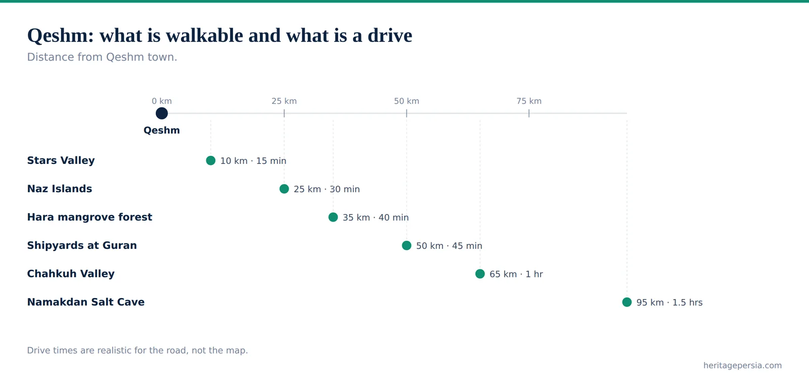
Distances are from Qeshm town, at the eastern end of the island near the ferry terminal.
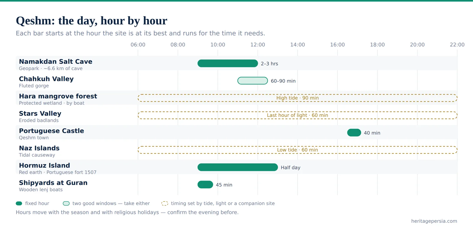
| Site | Time needed | Best hour | From Qeshm town | Why that hour |
|---|---|---|---|---|
| Namakdan Salt Cave Geopark · ~6.6 km of cave | 2–3 hrs | Morning | 95 km · 1.5 hrs | Far corner of the island; go early or the drive eats the day |
| Chahkuh Valley Fluted gorge | 60–90 min | 11:00–14:00 | 65 km · 1 hr | The sun has to be overhead to reach the floor of the gorge |
| Hara mangrove forest Protected wetland · by boat | 90 min | High tide | 35 km · 40 min | At low water the boats cannot enter. The tide decides, not the clock |
| Stars Valley Eroded badlands | 60 min | Last hour of light | 10 km · 15 min | The pinnacles only separate from the background when the sun is low |
| Portuguese Castle Qeshm town | 40 min | Late afternoon | In town | Ruined and exposed; pleasant when the heat drops |
| Naz Islands Tidal causeway | 60 min | Low tide | 25 km · 30 min | You walk out to them across the seabed — only at low water |
| Hormuz Island Red earth · Portuguese fort 1507 | Two days | Morning boat | Boat crossing | Cross in the morning, when the sea is calmer and the boats are frequent — then stay, because the colour sites want the last hours of light |
| Shipyards at Guran Wooden lenj boats | 45 min | Morning | 50 km · 45 min | Working yards; the men are there early and gone by midday |
Two of these sites run on the tide rather than the clock, and the tide moves by about fifty minutes a day. Ask your hotel or driver for the day's tide times the evening before and build the day around them — everything else on this list will fit around those two.
Namakdan — the Salt Cave
At the south-west corner of the island the Namakdan salt dome holds a cave of rock salt measured at about 6.6 kilometres, among the longest salt caves known anywhere and the flagship site of the geopark. It is not a show cave. There is no lighting, no walkway and no handrail; there is a stream of brine running through parts of it, salt crystals growing on the ceiling, and air that tastes faintly of the sea.
Most visitors walk the first section with a guide and a torch, which takes an hour or two and is enough. The floor is uneven and wet in places, the walls will mark light clothing, and anything metal you carry in will not thank you. Outside, the dome itself is worth the extra twenty minutes — a hill of salt with a salt stream running off it and a crust that crunches underfoot.
💡 Practical notes for the cave: closed shoes with grip, a head torch rather than a phone, and long sleeves. The drive is ninety minutes each way from Qeshm town on roads that deteriorate at the end, so this is the site that dictates the shape of the day — put it first, and pair it with Chahkuh on the way back rather than doubling across the island twice.
Chahkuh and Stars Valley
Chahkuh is the photograph you have probably already seen of Qeshm without knowing where it was. A gorge cut into pale rock in the middle of the island, its walls fluted into vertical grooves by rainwater running down them over a very long time, narrowing at the top end until two people cannot pass abreast. The walk in and back takes about an hour over dry sand and loose stone with a couple of easy scrambles.
The timing here is the opposite of everywhere else in Iran. Chahkuh wants the sun high, because the gorge is narrow and deep enough that low light never reaches the floor; between eleven and two the walls are lit from above and the flutes throw their own shadows. Villagers built water cisterns at the head of the gorge to catch what runs down it, and they are still there.
Stars Valley, fifteen minutes from Qeshm town, is the reverse case — a field of eroded pillars and gullies in soft sediment that needs the last hour of daylight to look like anything at all. The local name comes from a story that a falling star made the ground, and the guides will tell you the valley is avoided after dark. It is a half-hour walk down into it and back, and a good way to end a day that started in the cave.
The Hara Forest, and the Tide
On the strait between the island and the mainland stands the Hara forest — mangrove, growing in salt water, submerged to the crown at high tide and standing in mud at low. It is a protected wetland and the nursery for most of what lives in these waters, as well as a stop for migratory birds through the winter.
You see it from a small boat, and the tide decides entirely what that means. At high water the boat moves along channels between the tops of the trees with green on both sides at eye level, herons lifting off ahead of you; at low water the channels are mud, the boats cannot get in, and you are looking at roots from a jetty. The trips are sold by the hour and the hour is the wrong thing to ask about.
💡 Book the tide, not the trip: ask what time high water is on your day and take the boat within an hour or so either side of it. Any hotel on the island knows the day's tide; so does every boatman. This one question is the difference between the best ninety minutes on Qeshm and a wasted morning, and almost nobody thinks to ask it.
Hormuz — Worth the Third Day
A short crossing away sits Hormuz, which is geologically the opposite of Qeshm: iron-rich earth in red, ochre, yellow and violet, cliffs banded like a cut cake, and beaches where the sand is genuinely red. The island is small enough to circle in a morning in a hired vehicle, and the ruins of the Portuguese fortress of 1507 stand at the edge of the town — the same empire that built the castle in Qeshm town, holding the mouth of the Gulf for a century.
Travellers with two days should stay on Qeshm and skip this. Travellers with three almost always name Hormuz as the day they remember, partly for the colour and partly because the scale is human after Qeshm's — a small island, a small town, and a lot of red ground.
An Honest Word on the Beaches
Qeshm looks like a beach destination on a map and is not one in the sense that word usually carries. The rules on the Gulf coast are the national rules: women do not swim on open public beaches in ordinary swimwear, and where there is swimming for women it is at screened, designated sections or in enclosed hotel pools with separate hours. Men swim without difficulty.
We say this plainly because it is the single most common disappointment we hear about the island, and it is entirely avoidable by knowing in advance. Come for the salt dome, the gorge, the mangroves and the light on the water, and Qeshm is remarkable. Come for a week on a lounger and it is not the place, and no amount of planning will make it one.
What does work: long walks on empty shoreline, the Naz Islands at low tide when you can walk out across the seabed to them, boat time, and the food — this is the one coast of Iran where fish is the default and the Bandari cooking of the south, hot with tamarind and turmeric, is a real departure from the kebab-and-stew map of the interior.
Practical Qeshm
Getting there. Fly into Qeshm airport, or fly to Bandar Abbas and take the ferry, which runs frequently and takes under an hour. Domestic flights connect from Tehran, Isfahan and Shiraz. By road the island is around 1,100 kilometres from Shiraz, which is a decision rather than a detour — see our ten-day itinerary for where a classic route ends and this one would begin.
When to come. November to March. The island averages around 27°C across the year with June to August at the hot end and heavy humidity on top, and October to January at the cool end. Annual rainfall is about 183 mm and falls almost entirely in winter, in short bursts that can make the unsurfaced tracks to the geosites impassable for a day.
Getting around. Take a vehicle with a driver for the geosites; the tracks are unsurfaced and unsignposted and a hire car from the town is the wrong tool. Distances feel small on the map and are not — the salt cave is ninety minutes each way.
Where to stay. Qeshm town has conventional hotels and there are guesthouses in the villages, including a few built in local style with wind towers. The town is the practical base for a two-night stay because everything is reachable from it and the ferry leaves from there.
What to wear. The same national dress code as the rest of the country, with the heat and the sun as the added factor — see our dress code guide. Long loose cotton, a hat, and closed shoes for the cave and the gorge.
✉️ Thinking of adding the Gulf to a Persian route? Tell us your dates and we will tell you whether Qeshm fits or whether it is the reason to come back with four more days. Talk to our team →
Continue reading
Frequently Asked Questions
What travellers ask our guides about Qeshm, answered on the ground.
The Gulf, Done Properly
Salt cave, gorge and mangroves at the right tide — four days at the end of a Persian route.
Southern Itineraries →